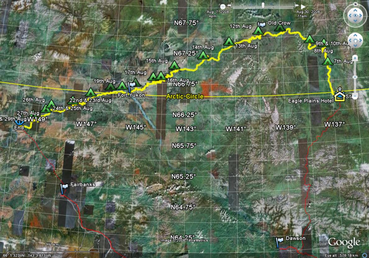
Log of Eagle/Bell/Porcupine/Yukon Trip
|
Wed 6th August
Anne and I set out from Whitehorse, getting to the South end of the Dempster Highway around 5pm. We had heard that the Dempster was in poor condition and was therefore slow going. Not therefore expecting to get to Eagle Plains for the hotel that night, we decided to eat a very early dinner at the place at the junction. Also fill with petrol. On the menu were musk-ox burgers. As we had not previously eaten any musk-ox, the choice was obvious.
As we were leaving a small almost flying saucer arrived in the form of a solar car on its way from Inuvik, the first solar car to cross the Arctic Circle.
The Dempster was nowhere near as bad as we had been led to believe, and we got to the hotel at Eagle Plains around 9. The restaurant there, however, closes at 8pm, so the decision to eat further south was a good one.
Thu 7th August am
 We ate a reasonable standard North American fried breakfast and set off for the Eagle River. The bridge is only about 10km north of the hotel and there was a turn off to a very muddy put-in point.
66 25.543N 136 42.714W
I put the boat on the soft mud at the water's edge and load everything, get in to the boat and slide into the water. I take a picture of Anne standing at the water's edge (well a bit back, on the firmer mud), then manage to hand the camera to her to take a picture of me departing. She cannot. The camera batteries choose this moment to die.

Anne fetches 6 spare batteries from the van, as my spare batteries are in the kitchen box, and not readily available. For the rest of the trip, I always carried 4 spare batteries in my little day box under the seat. I change the batteries in the camera, take another picture of Anne, she takes a picture of me, and off I go.
Thu 7th August pm
66 57.651N 137 6.090W
66.4km from Eagle Bridge via gps way points (WP)
703km from Dalton Highway via WP
On River ~9:10, off ~19:15
Dry, mostly clear all day, becoming cloudy and windy 20?km from (S)E
The put-in was muddy. The river is muddy.
At this pace I'll get to the Dalton Highway in 2 weeks. I have 3 1/2 weeks, and this pace is hard. On the other hand, I want a safety margin and all this is unknown.
The river is not as advertised. It is quite big, like the Yukon at Marsh Lake, perhaps, or maybe half that size. It is also quite fast. My slowest speed was 9.5kph against wind, and I touched 16+. The river is fast when narrow. Passed a heavily laden inflatable canoe on its 3rd day going to Old Crow.
Fri 8th August am
I slept 10 hours. I'm still moving like molasses. Light rain after a fairly cold night.
Camping is as advertised: tussock grass. Makes a strange sleeping surface.
There is a family of geese near here: I saw them going for a walk last night. I have also seen and heard a lot of raptors. One I saw close had mottled grey/white underwings. No other wildlife other than arthropods.
The river dropped about a foot overnight. Where I pulled the boat out there was a 4" step made of mud. I pulled the boat out and over about one boat width. In the morning, this step had slumped and there was a beach below. Launch was hard, but I'm glad pulled the boat in as far as I did (and tied it).
Fri 8th August pm
 67 16.067N 137 12.206W
115km from Eagle Bridge via WP
663km from Dalton Highway via WP, progress 40km
On River ~10:30, off ~18:!5
Slight, mostly ignorable, rain most of the day. Afternoon became windy
Camping is not easy on this river. Given that I have seen a change in level of 1' overnight, that high water is clearly 1.5m above now and LW most be at least 1m lower, I'd say the advice not to use sandbars (what sandbars?) is good. The banks are almost all either willow up to their knees growing in permafrost mud or just permafrost mud cut bank. Behind the CB or willow is almost always a row of poplar and behind that is stunted spruce and tussock grass. Climbing up the permafrost mud is messy. The horsetails do nothing to stabilise it.
Tonight the boat is staying in the water, tied fore and aft. I'll check it before finally retiring. Mud is definitely the enemy on this trip.
Today is day 2. Day 2s are always a poor day. I started late and finished early. Two reasons for stopping: (1) the next 5km are all NE against a horrid wind, and (2) my right wrist is suspect.
 Camp has a little stream, very little. I filled the water bottles from that. That way I avoid the river silt. The water is very brown, as brown as any peaty water in Scotland. I wonder if the permafrost muck is a valuable horticultural or agricultural resource. It is supposed to be rich in organics. Is it like peat? Can it be dried and sold? What is the CO2 cost of doing so?
I have not solved feet. With the "sealskin" socks my feet are dry, but even with socks, sealskins and booties my feet get cold.
So far there appear to be two omissions from the packing. There is no bivvy sack in my PFD. I could have sworn I moved one from Anne's to mine. And no wrist-strap in the first aid box. Again, I could have sworn there was one.
OK, boat check, photos of camp, last cup of tea, and bed.
Just as falling asleep, I heard wolves howling in the distance.
Sat 9th Aug am
Well, that's the first time I've had the safety off the bear spray.
I woke up at 4:45 and decided that despite it being calm and dry, getting up was not called for. (What really requires explanation is why I considered it an option!) Woke again at 6:45 to hear the kitchen box being moved. I looked out of the tent to see that a black bear had just turned it over on its side. I said, in a loud voice "Hello there, can I suggest that you leave that alone". The bear looks at me (well, the tent) and shies away and ambles off. I get up to examine the damage, carrying the bear spray, safety off. The kitchen box is on its side but the lid is still attached. The lid is muddy and has some black hairs on it that look remarkably like Baffin's. Bear had gone. I take a look at the boat: it is high and dry, held on the slope by its mooring lines. Launching it will be a game. I go back to the tent and back to sleep.
There was a lull in the rain. It did not stop completely. I got up and did breakfast and considered how to launch the boat. Rain picked up again. Breakfast in tent.
When I landed, I pulled in behind two willows that were in the water. They now complicate matters as they are on the bank and would stop the boat from sliding sideways into the water when the lines are slackened. I think I have to pull the boat forward to clear the aft willow, then back to clear the forward willow. The bank is very slippery, and I can not stand up without holding on to either the boat or its ropes. I have to slacken the aft rope and move the forward rope to make this work. Loading the boat will be fraught.
I've finished breakfast and my 3rd and last cup of tea. The rain is worse than ever and I have a choice to make: ignore it or cower from it. If this were last year the answer would be obvious: cower, but this year the weather has had a persistent pattern like this so it is likely to rain for days, weeks, until it snows. I'll cower hour by hour. It is still only 8:50.
Sat 9th Aug pm
67 20.667N 137 48.014W
150km from Eagle Bridge via WP 111km as crow flies
619km from Dalton Highway via WP, 552 as crow flies, progress 44km
On River ~10:30, off 16:30
Wind NE 10?. Rain, heavy for a while, cleared then 10% cloud cover but textured to thin

Head wind with slight rain to the Bell. The Bell is a big river. What I thought was a log swam to the shore and climbed out, but by then I was too far down stream to see what it was. Rain picked up and became hard, then slackened. The new rain coat, after a panic with zip failures worked well. 3? Caribou swam across and I got pictures of them on the bank. Shortly afterwards I got pictures of moose cow and calf. Later 3 big bull caribou swam across. I got pictures of the swim and of them on shore. At the Porcupine I saw 2 more caribou swim across, but it was too far away to get decent pictures.
The Porcupine at the confluence is huge, but becomes narrower. Downstream of here it looks like it goes through a narrow gap and camping may be constrained. Any excuse stopping early. A shingle beach! No mud! And unbelievably a porcupine on the beach to welcome me to the Porcupine. Plan is tea (with food) then dinner (ditto) later. I think I'm short rationing myself.

A boat stopped just as I was starting to unload: two natives looking for caribou. I gave hem them info they wanted. They seemed impressed at 3 days from the Dempster: "Going like smoke". Told them where I was going, which they translated as Stevens Village. Not surprised by that.
1st aid kit does contain wrist brace. Right wrist helped by it.
The peace and ease I find in the bush is being slow to manifest. I've felt snatches of it. This morning with the bear, and on the river with the moose and caribou. And this evening (finally) over dinner sitting staring across the river. But the all pervasive peace is not here yet. This sort of solo trip is very good at sorting out the soul, but I miss family camping. We did not do enough of it when the boys were that sort of age, and now it is difficult. Next year Tom and I have this big race to do. That will be different. I wonder if the year after I can talk either of them into a modest trip. Does the Wind count as a modest trip?
Sun 10th Aug
 Rain. It has been raining, mostly quite hard, since before midnight (as far as I know). Certainly it has been raining sufficiently hard to discourage even a brief excursion from the tent for the last couple of hours and it is now 9:50. The sky is uniform heavy grey and the hills are obscured by rain. This has the makings of a rain day. Sooner or later an excursion will be necessary.
11:10. No change. At noon I'll do breakfast even if the rain is still wet. I have noticed a mistake: the dry bags for the tent and tent stuff (sleeping bag etc) are outside, clipped to the tent, not under the fly. This means they are wet. For the sleeping bag especially this will make getting stuff into the bag difficult. It is a bit late, but I'll move them and hope they dry.
11:45. Eating breakfast. It is still very wet.
One could get a completely false impression of the vegetation here by going down the river The river is lined with willow, then a line of poplar and birch, then line of tall (normal) spruce. Behind that is stunted spruce, arctic willow, moss, lichen, and tussock grass. In fact, muskeg and tundra. But from the river it looks lush.
A bowl of porridge and a cup of tea or two do brighten one's disposition. But they do not change the weather. Before making breakfast I put the clobber bag under the fly and it is drying.
It is light until about 00:00. I do not need to declare this a rain day yet, but it shows no sign of change.
I should have said earlier: The 1st camp had mozzies. Last 2 have been largely free to the extent that I have the tent door open. Mind you, I think that one of Aragog's children set up home between the fly and the tent roof, so maybe I should have the door shut.
Note: on future trips, the fly and the tent should go in separate dry bags for wet packing.
12:40 rain as ever, but some discernable texture to the clouds
I may pack the log on top of the box under the spray deck for day access.
13:15. No break in the weather. Barometer set unfair.
14:40. Slight lightening in rain. I made tea and hot lunch. The break in the weather won't last. Looks worse, if anything, to South along Porcupine valley.
Yesterday was the first time I got my shoes out. I had warm dry feet. My shoes are now wet.
Porcupine water level is lower than yesterday. This summer must have been awful up here. The Bell was pretty clear water until the Eagle joined. The Porcupine is sufficiently big that it seems reasonably clear (relatively) after the Bell joined. The water from the Eagle did not precipitate out overnight, unlike the Yukon.
15:30. The rain has eased a bit, but there is lots more still up there. I thought I heard noises off, went out with camera, but saw nothing.
16:00. The sun is trying. It is still raining lightly, but trivial really. Things in the tent and vestibule are drying. I do not begrudge the rain day, even my shoes. I think I have spent the day constructively. Others may think otherwise. I've got the outline of the first half of an HP FF on paper. The second half is harder as the scope expands. And my tea has gone cold.
The sun may be winning: I can now see where it is, not that it is casting any shadows or anything, or that the rain has stopped. I went for a walk along the beach. The whole beach seems to be one wide stream except where I put the tent. Luck, not judgement.
Ha! A shadow!
18:45. We had some real sun and blue sky. Cloudy over the sky to NE and SW with just a blue strip here. There is clearly rain 1 or 2 km to the SW. It will take forever to get here, assuming it did: the weather turned soft, the hair on the back of my hand got damp without any obvious rain drops.
Sun again. Blue sky and cirrus clouds. With luck it will be a cold night and a clear day tomorrow. A beautiful evening.
Mon 11th Aug am
7:30. Breakfast made. I've had light rain since about midnight. Light rain is OK for paddling, but an embarrassment for taking down the tent. What is needed is a tent where the inside can be taken down before the fly. Was the Eyre tent like that? I would make sense. The Brits understand rain. MEC should too.
Mon 11th Aug pm
67 33.674N 139 03.010W
222km from Eagle Bridge via WP 161km as crow flies
547km from Dalton Highway via WP, 506 as crow flies, progress 72km

A long paddle today, a bit further than I intended as camp sites were hard to find. This one looks nice, but (unlike the last 2) is mozzie infested.
Just a short while ago two bull caribou got into the water just ahead of me. I chased them, getting some good photos, I hope.
At 14:30 I met a group of 3 + dog doing the same trip as me in 5 weeks. They were just loading their boats after breakfast! Apparently there is a German group also doing the trip on the river. I have not seen them. I may have passed them.

There are lots of game camps along the river.
Today I did 3 pages of Porcupine. If I do 1 page/ day and take a week from Fort Yukon to the bridge I get there Monday. There is no need for this hell for leather dash. But on the water one either paddles or gets cold. I suppose there is no reason to get up at 7.
I don't think I've been very good at finding camp sites.
OK. So the plan is this: tomorrow get well past Old Crow and look for a camp site. Then each day do a complete page then look for a campsite. Looking for a camp site can take up to 10 km. That should put me on a sensible schedule. Of course, if the weather is good one should press on, and if it is horrid, stay put.
Tue 12th Aug am
8:40. Have had breakfast. Beautiful clear blue morning. I've opened various things up to dry a bit. The river rose a bit during the night, about 4". The boat would be afloat if it had risen twice as much. But anyway, it is tied up, and if it had drifted it would have been caught 10m downstream. Mozzies slow this morning. It must be chilly. The ground I put the tent on is horizontal, but not flat. It goes up and down a good 10cm. Despite that, I slept well last night.
I have an invasion of whiskey jacks.
Tue 12th Aug pm
67 33.674N 139 03.010W
264km from Eagle Bridge via WP 187km as crow flies
504km from Dalton Highway via WP, 466 as crow flies, progress 43km
Set off 10:30, stopped about 16:20
 About noon a river boat stopped and asked about the couple in the inflatable canoe. Apparently they fly from Old Crow tomorrow and had phoned in for a ride. It does not surprise me that they had a phone: they were so loaded they must have had the kitchen sink. Nor does it surprise me that they were overdue. And that is with very high water on the Eagle. Not safe to be let loose.
The suburbs of Old Crow extend 40 km upstream and some distance down stream. My second attempt at a camp site was going well (nice landing, mostly accessible bench. Promising looking forest floor) until I saw a house through the trees. Damn. But this site is pretty good too. There are no useful sand bars to camp on. Maybe the river is higher than it was last year. Maybe I'm paranoid after seeing the Eagle drop 2' in 2 days and the Porcupine drop 6" overnight. Certainly the Wolf Creek lesson has been well learned: boat pulled or carried high and tied up. And the Spot comes with me. Quick release clips for spot and GPS would be nice.
I think Tom has it about right when we stop for lunch and "second lunch" I get the distinct impression that I'm metabolising "hump". Not that that is all bad. Today I'm having dinner and second dinner.
Lots of quite large "dog" prints by the river. No human ones. Not big enough to be wolf. Has Coyote made it this far north yet? Otherwise fox, I suppose, but that does not sound convincing. The prints are too big.
I wolfed two dinners. That's 1224 Cal. Mind you there are fast food meals bigger than that.
19:30. Weather is still clear and bright, but wind has picked up. I need to finish my tea and batten down the kitchen. The wind appears to be downstream, East still.
Now, schedule. I'm just off the Old Crow page. That's 10 gps km, nearer 20 river km. That puts me on the "Y-Z" page of the Porcupine, I did 2 complete pages today. 11 pages to go to Fort Yukon. 10 days to fort Yukon, 10 days from there to the bridge, perhaps.
Who am I kidding? The trip is sort of race tuned. I bet I do 2-3 pages per day down to Fort Yukon (more to begin with, then fewer
... the later pages look long) so perhaps 5 days and 5 days. Oops. Oh well. At least Anne can see where I am each day and make some sort of decision…
Wed 13th Aug am
Last night I carried the boat way up the beach so I could tie it to a substantial willow. This morning its stern is in the water!
Light overcast.
Wed 13th Aug pm
 67 20.825N 141 14.817W
322km from Eagle Bridge via WP 223km as crow flies
446km from Dalton Highway via WP, 409 as crow flies, progress 58km
Set off 09:10, stopped about 14:30 ADT
The first page of the map took almost 4 hours. I was expecting that. Then into the Ramparts: a long straight canyon, narrower, faster water.
I heard something on the shingle beach as I paddled. It was Coyote. He stopped and I looked down for my camera. I looked up and he had vanished … until he moved his head. His camouflage was perfect. No point in taking a picture, no one would see he was there.
The Ramparts are fun. Spectacular and quite fast. Lots of pictures of rock formations. Probably like my father's pictures of Bryce canyon when I was small: too many and eventually just boring.


I stopped just short of map mark "2" for a high, dry, windy campsite. It might rain. It has been threatening on and off all day.
Crossed in the USA 14:30 PDT, 13:30 ADT.
17:20. I have eaten, two meal packs and climbed to the top of the ridge.
It is pretty windy (from E still). I hope I do not have W winds to make up for it in the Flats. I've guyed and pegged the tent for the first time this trip.

 If the weather etc. is favourable, I could get to the bridge 8 or 9 days early. I wonder if Anne knows that and what she is thinking. The Spot help message says something like
"delayed: reschedule pickup". If I sent such a message once I'm past Fort Yukon and when I am clearly not delayed, will that work? I can only expect a Saturday or Sunday pickup, that is clear. If I were Anne and there were doubt, I'd take the Monday off and drive Saturday to be at the bridge Sunday am. I should aim for Sat pm.
If the weather etc. is favourable, I could get to the bridge 8 or 9 days early. I wonder if Anne knows that and what she is thinking. The Spot help message says something like
"delayed: reschedule pickup". If I sent such a message once I'm past Fort Yukon and when I am clearly not delayed, will that work? I can only expect a Saturday or Sunday pickup, that is clear. If I were Anne and there were doubt, I'd take the Monday off and drive Saturday to be at the bridge Sunday am. I should aim for Sat pm.
I should note that while pushing through the bank willows a twig managed to go behind my glasses, and without knocking them off, scratch my right eye. Last time that happened was in Scotland, and was followed by a trip to ER for a drop of local in the eye so they could examine it. The local felt good too. No such option here. It is not very uncomfortable, or very bloodshot. Maybe a follow up in Whitehorse.
Thu 14th Aug am
Still very windy in gusts from E. Also bands of light rain. Should be OK on the river. My eye is still sore, but not too bad.
Thu 14th Aug pm
 67 07.343N 142 20.396W
377km from Eagle Bridge via WP 356km as crow flies
392km from Dalton Highway via WP, 356 as crow flies, progress 54km
Set off 10:10, stopped about 16:40
Mostly/entirely overcast all day, wind strong E maybe NE
I paddled about 10 km further than I intended today. Out of the Ramparts. I am now about 10 km (actual) to "5";, then 2 fairly straight pages to "7", then the river gets lost from "7" to Fort Yukon. Could take 5 days, or 3. I have no idea.
I think the burn rate on tea is too high. I'm drinking some Cytomax (hot) instead with 1st dinner.
Attacked by blackfly here.
My eye is still a little sore, but there are no new symptoms with it.

I'm a bit zonked. Actually I probably gain a little insight into what Anne feels like on these trips. When one lands at a tentative camp, one identifies possible tent site(s) and a kitchen. After that it is pretty automatic… except it's not. Often there are several things that need doing, and if sufficiently zonked, one can get stuck deciding the order in which to do them.
It is about time to do second dinner and take camp photos. I keep forgetting them.
There have been, perhaps, some seasonal changes over the last week. First is that I'm seeing a lot more yellow than I did a week ago. Second is that a week ago I saw geese in family groups, now they are in larger groups.
18:40. It just started raining lightly (later note: wind in trees… not rain)
Fri 15th Aug am
 Uniform grey sky. Looks like a light wind from East. Right eye no longer sore, but orbit is a bit sore to touch; it may still be a bit puffy. On the other hand, some @#$%^ insect has bitten me on the outer orbit.
Today ought to be another fine paddling day. I should get well onto the "7"-"8" page. Why the lack of enthusiasm?
Fri 15th Aug pm
66 57.157N 143 31.722W
 334km from Dalton Highway via WP, 301 as crow flies, progress 58km; over half way!
434km from Eagle Bridge via WP 306km as crow flies
Set off 10:10, stopped about 16:40
Well, a number of firsts. This is a sort of sand bar camp like the ones we used in the flats last year (a first for this trip) and it has signs of having been used before (another first). There are also some black and grizzly bear prints. Anyway it is a pretty nice camp site.

I unloaded the boat, carried it high up the beach and tied it up, and had just unrolled the tent when I see the head of a black bear about three bear lengths from all my stuff on the beach, swimming towards the shore. I move quickly, but not running, to the stuff and extract the bear spray and camera. I also advise the bear that it is not welcome. I think this bear is deaf. It lands (about 10 metres downstream) shakes, and starts to walk towards me. I am busy taking pictures of this. The bear gets to within my comfort zone and, as the wind is behind me I can be sure of several things: the bear can hear me, the bear can smell me, and if I pull the trigger the bear gets a face-full, not me. So I fire a ½ second shot. This is at 5 metres so is not a concentrated nasty dose, but should discourage. The bear notices, turns, and ambles into the bushes behind where the tent will be.
Now what? Have I cocked up? Is there a food cache or den back in there? I peer into the woods (talking all the time) half a minute later I see the bear again 25m downstream. He heads back into the water and swims off. I see him cross the river and make a real hash of climbing out the cut bank the far side some distance off downstream.

Now back to putting up the tent.
Well, I've put up the tent, changed shoes, eaten first dinner and had a cup of tea. Every log still looks like a bear, especially one on the far bank upstream of here. It looks like a short nosed tundra bear.
Anyway, there I was sitting on the bow of the boat finishing my cup of tea when, blow me, I see another black bear making land-fall just upstream (and up wind) of me. So I tell the bear what I think and it jumps and runs into the woods. I grab the camera and bear spray. I have not seen this bear leave, but I'm not on an island. I went to investigate where the bear landed and went into the woods. If there is to be another encounter, I wanted to be up wind of it. Anyway, my crashing and exclaiming things like
"where do you think this is? Paddington bloody station?" result in some huffing and crashing off in the woods. We'll see. How many black bears can there be here anyway? They were not the same bear. The second looked much younger, but pretty much full size. In its prime, in fact.

Note: in the future, hold on to the safety catch as you pull it off the can. That's twice I've had to play hunt the thimble for the safety.
Later note: there is a little chain on the safety that can be used to attach it to the trigger mechanism
Later note still: the chain is useless. You pull off the safety for real, and it breaks.
I suppose this must be a natural crossing point or something. It is not obvious that this is a silly place to be. Other than the apparent high bear population.
I did not get a good picture of the second bear
I think some camp reorganisation is called for: the kitchen is too close to the tent, and upwind of it.
Sat 16th Aug am
No sign of bears in the night. I spent a slightly twitchy night though.
Light cloud cover. Moderate wind from upstream which I thinks means SE, but who knows… the wind tends to follow the river.
11:10, under way:
 Just before pushing off, I stopped to listen to the duet of a pair of loons preparing for their migration. Loons are about the most monogamous of all creatures, and their migration is odd. The males leave first, the females later when the young are ready. They overwinter separately, then the males return first to rebuild their nest and await the return of their mate. If she does not return, he will wait year after year for her.
Anyway, the duet spoke of distance and love and longing and loneliness; a lingering song that tears at the heart and calls to the soul. But this song of farewell was to be a goodbye. A bear who was up to his ears and nose in the water at the far bank grabbed one loon, and a few moments later, the other who had made no effort to escape. I suppose bears are tone deaf, or have no soul.
The river was strangely silent for the next hour. Even the wind seemed stilled. But are we different from the bear? We eat lamb and cow. So let us forgive the bear for being a bear and move on.
The silence was finally broken by that most prosaic of sounds, the caw of Raven. This seemed to reset the mood, and shortly I heard a flock of ducks squabbling, and a little after that, a skein of geese, a couple of dozen or more, flew overhead forever arguing about position, precedence, direction, or whatever it is that concerns geese so much.
Sat 16th Aug pm
 66 46.286N 144 04.306W
305km from Dalton Highway via WP, 272 as crow flies, progress 29km
466km from Eagle Bridge via WP 328km as crow flies
Set off 10:00, stopped about 15:30
Clear blue sky, little wind, fluffy clouds to west
A very slow day. Slow water, slow paddling, very slow page. I actually went further than I intended looking for a campsite. My first intended site looked good, but was overlooked by a plywood shack. Second place was not very good. Third was good except for the pair of black bear cubs playing near the beach. The forth is OK. I got a couple of pictures of the bear cubs.
I saw a gang of ravens flying high playing in a thermal, pretending to be eagles.
I almost miss the screech of the falcons that so marked the Eagle, Bell, and Ramparts.
I need to walk around a bit to stretch my back.
7:45: still clear blue sky. Light wind from ?SE, cumulus clouds to W or SW (on Yukon River)
Sun 17th Aug am
Strong NE wind. Blue sky, some cirrus. A little cloud on SW horizon.
Wagging finger trees have ceased to bother me as much as they once did. They are not usually indicative of shallow water. They are trees dropped by the ice. Erratics, as it were.
It is still a bit cool in the wind, but I'm expecting a warm day.
All I need to do now is to work out how to stop falling ahead of schedule.
It is getting windy. The N and E sections will be hard!
Sun 17th Aug pm
66 45.212N 144 23.135W
289km from Dalton Highway via WP, 258 as crow flies, progress 16km
479km from Eagle Bridge via WP 342km as crow flies
Set off 09:50, stopped about 13:50
Clear blue sky, little wind, fluffy clouds to west
 OK, this constitutes an attempt to go slowly. I stopped before 2pm!
Met an old German on the river. Put in the week before me on the Eagle. Has a plane to catch in Fairbanks on 29th.
It continues to be a beautiful sunny, windy day.
Where I've pitched tent is more or less the start of a long clearing in the poplars, like a road. It was probably made by ice or a rogue log swept down in a spring flood a few years ago.
There are footprints in this clearing, old and new. Black and grizzly, adult and young. And bear shit too, old and new. The most recent I found can not be more than 2 days old.

The undergrowth below the poplars is rose (in fruit and looking succulent) and those white berries.
Well, I'll try not to disturb the bears. I hope they return the favour.
Correction. The roses in the forest have been mostly stripped. They are bare, rather than bear food, for they no longer bear fruit. No more, I can not bear it.
Went for a little walk. Makes less sense without Anne and Baffin. But I saw some teeny weeny little grizzly prints (blacks have round feet, grizzly have the toes in a line)
Mon 18th Aug am
Clear blue windy perfect early autumn day
Why no motivation? It is a beautiful day for a paddle, and I can do 4 hours for 20 km progress.
Mon 18th Aug pm
 66 38.685N 145 06.429W
258km from Dalton Highway via WP, 224 as crow flies, progress 31km
515km from Eagle Bridge via WP 373km as crow flies
Set off 10:10, stopped about 15:15
Still very windy from NE and clear blue sky with some trivial cloud on South horizon.
The camp is mostly sheltered by trees, but walk down to the water and get blown away.
I am about 1½ hours from Fort Yukon. The plan is to go into town early and phone Anne for pickup Sat 30th instead of Mon 1st. She can also report my crossing and get the Fairbanks immigration office opening times and, if that is inconvenient, if I can report to immigration at AlCan instead.

I saw several boats on the water today. No surprise being this close to Fort Yukon.
If I am to get to Fort Yukon early, say 9, then I need to be on the water at about 7:30, get up about 6. Better get to bed early.
Tue 19th Aug am
06:00. Bright clear dawn, wind still ~N, not as strong (yet); bit sort of brass monkey this time of day.
Tue 19th Aug pm
66 35.174N 145 38.628W
213km from Dalton Highway via WP, 200 as crow flies, progress 45km (but I suspect a discontinuity here)
543km from Eagle Bridge via WP 397km as crow flies
Set off 07:45, stopped about 13:20
 Well, I missed the clever turn into Fort Yukon, took the other back channel and paddled upstream on the Yukon for about 1½ km and walked to the store getting there about 10:10. They open at 10. Bought Tea and a phone card. I out-stared the Doritos. Then I went to the airport to use THE payphone. Now it is hard to miss an airport, but you have to guess where the
"terminal building" will be. I guessed that it would be in the corner nearest town. I was right. There was a cluster of 3 buildings there, none looking that convincing. I stood around uncertain for a bit, then asked someone. They told me I was standing in front of it. I asked how to get in. They told me to use the front door. Where's that, I said. At the front, he said. Ah, I said. Silly me, I was expecting the front to face the road. It faces the airport. I go in and use the phone. I could not get hold of Anne, but I got Tom. I left a message for Anne with Tom and on the answering machine at home to
"pick me up the Saturday, not the Monday"
Well, I missed the clever turn into Fort Yukon, took the other back channel and paddled upstream on the Yukon for about 1½ km and walked to the store getting there about 10:10. They open at 10. Bought Tea and a phone card. I out-stared the Doritos. Then I went to the airport to use THE payphone. Now it is hard to miss an airport, but you have to guess where the
"terminal building" will be. I guessed that it would be in the corner nearest town. I was right. There was a cluster of 3 buildings there, none looking that convincing. I stood around uncertain for a bit, then asked someone. They told me I was standing in front of it. I asked how to get in. They told me to use the front door. Where's that, I said. At the front, he said. Ah, I said. Silly me, I was expecting the front to face the road. It faces the airport. I go in and use the phone. I could not get hold of Anne, but I got Tom. I left a message for Anne with Tom and on the answering machine at home to
"pick me up the Saturday, not the Monday"

Paddled on from Fort Yukon. Very strong N wind. The tent is well guyed down. It tried to take off as I put it up.
I sit in the kitchen cowering behind a clump of willow that is doing a fine job of blocking the wind. Sky is still clear blue.
If the wind was like this from the west, the water would be different. As it is it is just a little choppy.
The water is noticeably higher than last year. I will not be able to compare speeds, but it will be interesting to see how this affects camp site availability.
I've had pretty much continuous N or NE winds this whole trip. I'm expecting that to change to W or SW about now.

The last day on the river, I have to cover at least 19 gps km as there are no camp sites after that. In fact, I'll probably stop another 12 km upstream, so 30 km. That leaves 183 gps km to be divided amongst 10 days. That's ¾ of a page a day. I did ½ a page today after leaving Fort Yukon *sigh*
Last trip we did 3 pages the day after the camp just past Fort Yukon, then 1½, then 1 (but with massive head winds and a stupendous hail storm), then 1½, then 2¹/3. If I'm not careful, I'm going to be very bored.
While I'm here I'm checking my channels and channel marks for next year.
The stove is playing up again, both pump and jet. I have the bits, but it is gritty and blowing just here.
Wed 20th Aug am
Beautiful clear blue sky. Strong NE wind. If I had a mind to I could get most or all the way to the bridge today in these conditions. Instead, I've overshot my quota if I turn the page.
Dew on the cook box this morning. It was out of the wind. Everything else is bone dry.
The river is much clearer than I remember it. Are the Eagle, Bell, and Porcupine that bad?
Last night around 1:30 there was day glow in the North plus an aurora and a moon to the south.
Wed 20th Aug pm
66 33.722N 146 06.800W
190km from Dalton Highway via WP, 179 as crow flies, progress 23km
566km from Eagle Bridge via WP 418km as crow flies
Set off 11:30, stopped about 14:15
 Investigated a potential "fast channel".
One of the things I want to do on this section is to verify that what I said about campsites in the flats — that you can find one within half an hour or so — is true. It appears to be, so far, but you can find yourself is some god-awful moonscapes. Finding a half decent camp site is harder. Much harder by yourself. I think that some of last year's camps would have been pretty bleak without company.
This camp is different. It is not a sand bar. It must have been wooded until this little bit got cleared by ice about 10 years ago. Landing was a challenge. First, I was the wrong side of the river and did a heroic ferry to get here, and a few metres upstream when I did get to this bank. Then the
"beach" is only about 2 boat lengths and is mud, deep soft mud. The boat is now up on the bench.

Putting up the tent was different too. I erected it then got in to squish the vegetation so I could peg it down. The vegetation is so lush that if I put anything down or drop anything it is lost.
A popper [snap fastener] has failed on the spray deck. I do not have the fixing kit for that. It will have to wait.
Note that I made 23 out of my allotted 18 km progress today. That is with following some random channel and zigzagging to and fro looking at possible camp sites.

Having put up the tent I sort of stood there uselessly not sure what to do next. Routine has been: land, 1st dinner + tea, write log and chill, 2nd dinner + tea, bed. But it is only lunch time. So I had a power bar (I over provisioned them) and made tea. I can be more free with tea since I bought some in Fort Yukon. Red Rose, yet. I thought that was a Canadian only brand, but this is US packaging. 100 bags with free "lovable porcelain figure". So the boat is now equipped with a small, hideous green, porcelain budgie. No expedition is complete without one.
Last night, for the first time this trip, I took no precautions against bears. They just could not be interested in that area. This camp is different. I may stay 2 nights. I hate to waste such perfect paddling weather…
19:15 The wind is now east and very light with occasional puffs (can hardly call them gusts) sky is still clear blue. Current plan is to stay put tomorrow. That will mean doing 20 gps km/day from then on, or perhaps 40 every other day.
Thu 21st Aug
Clear blue sky, Gentle wind from E.
This vegetation is lumpy, but fairly soft. Once you have found a position that works you can sleep well. There is a lesson here for next year's race: do not compromise on mattress pads
Today might be a good day to try the experiment I've been meaning to try: if I stay in my sleeping bag, how long before anyone brings me a cup of tea?
Tried to go for a walk. The island I'm on is about 1km by 3, but outside a radius of a couple of hundred metres the bush becomes too dense for useful progress, at least not without risking eyes etc. There are odd clearings and paths. These may be random artefacts, or may be made by animals.
I can sit and stare at the county level, but this is Olympic.
16:00 wind NE, breezier, still gusty. Some cirrus and little clouds on East horizon
Other than any attack on camp by dragons and bandersnatch, nothing happened today.
17:30 Hazy to west. Lots of cirrus. Weather may yet change.
I feel really twitchy about not paddling on a perfect day. My instinct is to gun it to the end, or at least within 50 km of the bridge. At least by stopping here the day, Anne won't mistake my intentions and go to the pickup a week early. If I do another 50-70 km tomorrow, no problem (except spilling time). 3 paddling days @ 50km, 40 on Saturday leaves me 5 days of sitting and staring. I could make a drafts board in the sand and use pebbles.
Fri 22 Aug am
Yet Another Clear Bright Blue Morning. Slight breeze from east. Ice on the tent last night.
Fri 22nd Aug pm
 66 26.493N 146 54.729W out of the Arctic
147km from Dalton Highway via WP, 141 as crow flies, progress 43km
609km from Eagle Bridge via WP 455km as crow flies
Set off 10:05, stopped about 16:40
Wind from East. Clear blue sky. Perfect on the river, need a fleece on land
I am camped at what is marked on the map as "camp 8" from last year. I do not recognize it. It looks like a typical place I'd camp. I'm sort of glad I do not recognise it. I already miss Anne and Tom on this trip. It would be too poignant.
It is probably worth noting which side of the river the various river boats use.
I suppose I stay here 2 nights.
The next pot will be the last of the Boh tea, then onto the Red Rose I bought in Fort Yukon.
21:45. Wind has dropped. Sun is setting. Moon has risen. Sky is still clear.
Sat 23rd Aug
 08:00. Clear blue sky. Wind picked up again, E or NE
Not up yet. No hurry. Not going anywhere. I still feel I could regret this and find myself with 200km of battling 30kph head winds and 1m waves and rain or sleet or snow
09:30. That is a bitter, cutting wind, but with sun like this it should warm up
17:00. I'm astonished how long this strong easterly weather system has lasted. It is still clear with strong winds from the NE. And I'm sure I'm right to be concerned. It is a big river and winds like this from the W would whip it into a frenzy. I'm wondering if the wind has not become stronger and more N. Little sense in worrying about it now, but note that the wind tends to drop late evening and start to pick up around sunrise. I might find myself paddling at some strange hours.
Sun 24th Aug am
Clear blue sky, chilly wind from NE
For chilly read cold, bitter, cutting. If there were any moisture in the air I'm sure we'd have a frost.
Sun 24th Aug pm
 66 17.252N 147 36.728W
109km from Dalton Highway via WP, 108 as crow flies, progress 38km
648km from Eagle Bridge via WP 488km as crow flies
Set off 09:30, stopped about 13:40
A good ½ day's paddling. It was warmer on the water than I expected, which resulted in much peeling off layers. The NE wind made a lot of itself in places.
As I approached Beaver, a plane buzzed the village: standard bush operating protocol to ensure the runway is clear. In this instance it had another effect, I think.
As I paddled past Beaver, I saw a bunch of people standing on the bank opposite the village, which seemed odd. They had a fish wheel there, which seemed very odd, and it was turning, which, given the moratorium on salmon this summer seemed very odd indeed. At this point a river boat came across from Beaver with a heap more people. Can this get and stranger?
Some of the people in the boat started taking pictures of me. Suddenly all is clear. This is a setup for tourists!
I look at "camp 9". Either we were not fussy about camps last year, or it has changed. I'll put money on the second option. The area was covered in dead wood from this year's breakup. So instead, I camped a little further downstream. That was a bit of a ferry, and I could have made a better landfall. The beach is steeper than I thought, so the boat turned less than I expected on approach, so still had some 60 degrees to turn as the bow touched. I was also moving down stream slightly more than I expected. Nevertheless, land. Nice enough camp. Back into the straight willows with the occasional bigger willow to break the wind.

Some cirrus and thin clouds to the South. This morning a cloud covered the sun. mostly. It was not big enough to occlude the whole thing.
I've sorted the food some, making sure I eat the better rather than the less good freeze dried stuff.
So the plan, insofar as there is one, is to spend Sunday and Monday nights here, paddle to somewhere past where we cowered from a hail storm last year and spend Tuesday and Wednesday there, paddle around to the back channel before the canyon and spend Thursday and Friday nights there, getting to the bridge about 12 on Saturday.
At this point I rather miss the camp chairs. Could do with one to sit in to sit and stare the better,
19:00. Wind almost calm. Drift from ENE. Some cirrus and stratostratus.
Mon 25th Aug
09:00. Wind almost calm. Drift from ENE. Almost clear blue sky. Fly soaking wet despite both doors being open all night

A helicopter flew down river after I had had breakfast, and yes, it was black. I should have brought some aluminium foil with me so they couldn't find me.
12:00. Went for a walk around this island, or near island. I went downstream to where there is a muddy, high water channel and followed it round to the real channel at the upstream end, then followed that back to the main channel and back to camp.
 Wildlife exists in the back channels. Fantastic numbers of geese, black and grizzly bear and moose prints in the mud.
The island is mostly vegetated by narrow leaf willow. This is a colonizing species. The island must have been cleared by ice or such a few years ago. Anyway, the narrow leaf willow grows straight up with no branching, so it is easy to push through. The upstream end of the island is broad leaf willow and poplar. The broad leaf willow grows in classic willow fashion with many stems from one clump. This is harder to push through. These willows had also been broken a few years ago by ice, so there was old dead willow horizontal at about knee to thigh height to impede progress. But there were paths made by moose and bear and I used those.
After lunch I redid the stores. I now have everything I need for cooking, including the food, in the kitchen box. The two food bags have become one food bag and one rubbish bag. This has a side effect of shifting some weight aft (to the food box), but also of consolidating the forward cargo further forward, so trim should still be good. I also mucked out the boat a bit, clearing out old power bar wrappers.
I have enough spare food for about 10 days paddling, 20 days survival, not counting the food for this week. I have burned a little less than 2.5 litres of petrol, and have just over 4.5 litres left.
There are fluffy clouds N and E. They could grow.
17:00. The clouds grew to about 30% coverage. The wind picked up a bit, then dropped and the clouds dissipated. Back to a light breeze from the ENE.
Yellow is now clearly the predominant colour of the narrow leaf willow. The broad leaf willow is about half and half yellow and green with the occasional splash of red. The poplars remain green.
The wind is a fitful little drift from ENE. It looks like clouds to SE. The next section of river we paddled last year in the teeth of a strong west wind, and sat out a spectacular hail storm.
Tue 26th Aug am
Warmer last night than of late. That is probably because it clouded over. Now we have broken clouds 7/8, clear to SW. 8/8 to N and E. No wind
Tue 26th Aug pm

66 11.534N 148 28.501W
68km from Dalton Highway via WP, 66 as crow flies, progress 41km
688km from Eagle Bridge via WP 527km as crow flies
Set off 09:30, stopped about 14:20
The weather can not make up its mind: sunny/cloudy, windy/calm, from E/W.
Welcome to Lake Yukon. The current seems more or less absent just here. I investigated a possible shortcut which might have helped next year.
This camp is a bit iffy. Muddy beach (I think that goes with the current) and only limited tent space up against the willows in a patch cleared by ice I'd say about 2 years ago.
 I pulled the boat up the beach and it is now right across some beautiful grizzly bear tracks.
I pushed the OK button on the Spot device as I went into the putative short cut. I figured that no one would find me in there if something went wrong otherwise and there was a risk. It was a bit like the Mclintock river, being bendy with sweepers, but had been attacked by Yukon scale ice.
Water in this camp is going to be a game. The beach is shallow and muddy.
I'm also running low on Pristine, the water purification drops.

I may do some paddling tomorrow or Friday, otherwise I have quite a long paddle to do.
After some tea Id better go and "mark" camp. I don't want to surprise a grizzly bear any more than necessary.
The beach almost reads like a compendium of subarctic carnivores, except no cats. Grizzly bear, black bear, coyote and (I think) some member of the weasel family.

I think it is about 110 river km to go, about 36 of which have to be done Saturday. So 84 for Wednesday, Thursday, Friday. Camp 11 is almost exactly half way. Not that it was a great camp. Tomorrow or Thursday I should paddle and look for a camp somewhere on the penultimate page, The Friday look for a camp in the back channels on the last page. If I fail to find any, no big deal: I get to the bridge a day early. Shame I have almost no respectable clothes with me.
The tent is showing signs of needing attention: joints on the poles need cleaning/lubricating, the door zips need the silt cleaning out of them, and the fly vent covers have problems with their stiffeners. I don't know what to do about that last problem.
I'm working on the assumption of paddling tomorrow. I have just enough water for breakfast.
This evening's food pack was American with Canadian labels. This includes what they presumably think are French instructions and ingredients lists. Oh dear.
20:00. Clear sky, no wind.
Wed 27th Aug am
7/8 cloud. Breeze from E? Chilly morning. Fly soaking inside and out.
In the night there was a kerfuffle amongst the geese somewhere near here and a deep growl. I winder if Bear got Goose. Then in the early morning I was awoken by the combined dawn chorus of all the geese on this part of the river. A cold sound. A cold grey morning.
From here on, the river is characterised by mud flats, log piles and cut banks. Plan is to cover 10 gps km and start looking for a good camp site. After another 10 km, become less fussy. If there is nothing in the following 20 km, I have a problem: once you are in the canyon it is all cabins and fish camps.
10:00 I suppose I should do something
Wed 27th Aug pm(just)
66 06.606N 148 40.866W
54km from Dalton Highway via WP, 54 as crow flies, progress 14km
698km from Eagle Bridge via WP 538km as crow flies
Set off 10:50, stopped about 12:10
Light E wind. Very complicated sky
 Shortest paddling day yet. Possibly ever. But this is a nice enough campsite, although I had to squish a few willow to make room for the tent. Moose, Black bear, coyote prints present.
Camp is just before that big meander to the south on the last leg of which we made our last camp last year. I suppose I could 2 more days with paddles this length before paddling out Saturday. It depends on what the banks look like. I'm a bit concerned that there may be almost nowhere to camp reasonably between here and the bridge. If I think there aren't, then I'll stay here 2 days and if I find a camp on Friday, good, if not no real problem. See what I think tomorrow.
Add Grizzly bear to the list of foot prints, and those canid prints might be Dog. I see human foot prints too.
Washed and bathed in the river.

18:00. Sky a mix of blue and thin grey. Light breeze from E?
I calculate ~8 hr paddling left, 3 hours Saturday. Timing on Saturday is an interesting problem. I suspect Anne will drive Friday to Fairbanks, and up the Dalton Saturday. I think it's about 3 hours from Fairbanks to the bridge, but that is an unknown. The tourist bus took 4 ± hours, but that included several stops. So say 3 hours. Anne will want (a) to arrive to see me arrive, and (b) won't want to wait long. She may do the same calculation as me and decide I'm unlikely to get there before noon, and aim to get there close to noon. Or she may decide that this pickup is doing me sufficient of a favour without getting up early in Fairbanks. In that case she will be at the bridge 13:00 or 14:00? This speculation is futile. I'll aim for noon. After all she may go straight to the bridge and be waiting impatiently. I hope Anne brings a set of shore-going clothes, shampoo, nailbrush, razor.
I heard voices. I investigated as my camp is nearly invisible and I do not want to be shot by mistake. There is a camp, about 45 degrees down stream across the river. Voices carry well over water. Remember that.
 21:00. Well he/she was fat and sleek and beautiful, but too close. A black bear came almost up to the tent with me in it. I got up and armed with camera and bear spray (safety off, little chain broke) told the bear to go away. Bear was reluctant to comply, and huffed at me. So I advanced telling Bear that it was MY camp and to b***er off. The bear backed away, but tried to circle back. I was beginning to get a bit peeved with Bear. Blacks are supposed to be timid and run when you say
"boo". That theory is running at 50% this trip. Anyway, I threw a piece of log towards Bear, not to hit, but as a warning. The log lands and rolls to Bear's feet. Bear circles a bit wider, towards the river, and, blow me, decides to investigate my boat. I advance quite quickly saying in a loud voice (and I have a loud voice)
"Listen, you piggy-eyed, hairy arsed brute, that is MY effing boat. B***ger off". Bear retreats a little. I fire a shot of bear spray at him. Bear is maybe 7 metres away, so the spray is not offensive, just unattractive. Anyway, combined with more invective, he decides to amble up the beach and away.
21:00. Well he/she was fat and sleek and beautiful, but too close. A black bear came almost up to the tent with me in it. I got up and armed with camera and bear spray (safety off, little chain broke) told the bear to go away. Bear was reluctant to comply, and huffed at me. So I advanced telling Bear that it was MY camp and to b***er off. The bear backed away, but tried to circle back. I was beginning to get a bit peeved with Bear. Blacks are supposed to be timid and run when you say
"boo". That theory is running at 50% this trip. Anyway, I threw a piece of log towards Bear, not to hit, but as a warning. The log lands and rolls to Bear's feet. Bear circles a bit wider, towards the river, and, blow me, decides to investigate my boat. I advance quite quickly saying in a loud voice (and I have a loud voice)
"Listen, you piggy-eyed, hairy arsed brute, that is MY effing boat. B***ger off". Bear retreats a little. I fire a shot of bear spray at him. Bear is maybe 7 metres away, so the spray is not offensive, just unattractive. Anyway, combined with more invective, he decides to amble up the beach and away.

I should mention that all this time I am wearing a T shirt and that is all. Even bare feet. However I think I got some good photos of Bear. One thing that surprised me was my attitude. If that short shot of bear spray had not worked, I was going to use a full blast at close range, and while the bear could not see, hit it hard over the head with a log.
Now every bird in the willows, every fish in the river sounds like a bear. And some mozzie got me. But damn, got to defend camp.
So that is what, 8 bears this trip, 4 in camp? And I really do keep a clean camp, especially when solo.

I feel a little guilty using the bear spray. It says for use on aggressive bears. Bear was not aggressive, just curious. OK Bear huffed at me, but I was saying some pretty harsh things to Bear. Oh well.
*grin* Bears have really small genitalia considering their size. So if it was a matter of waving dicks around, mine was definitely bigger, even if he was hairier. I don't even know what sex bear was. Difficult to see with all that hair and it really makes little difference to me.
Thu 28th Aug am
Calm. Light broken cloud. Soaking wet fly
Thu 28th Aug pm
 65 59.471N 149 10.581W
28km from Dalton Highway, progress 28km
728km from Eagle Bridge via WP 562km as crow flies
Set off 10:30, stopped about 15:00
Very thin cloud 2/8, light breeze from E
Progress makes it look like I did half the remaining distance. Hah. I did all the big meanders. It is now ~36 river km to go, 2 ½ - 3 hours, which I'll do Saturday.
So here was I paddling down the upstream side of the really big meander, just thinking it was time to work my way across to the far side to follow the current. The right side, the inside of the meander, is going to get shallow and slow. I see a log in the middle of the channel, and think nothing of it. A little later I realise that the log is not moving with the current , so I think "How is it that shallow all the way out there?" and adjust course a little.

A little later still, I realise that this log is not stationary with respect to either the water or the banks. Now logs don't normally behave like that, so we re-evaluate. It's another bear. So out with the camera and I take some ho-hum pictures of Bear as I drift by. Then I think, "Ha! Water is my element, not Bear's", and chase it, getting a few good shots, I hope. I get really quite close to Bear. Black bears, at least, can not swim very fast. Bear is not impressed, makes a splashy landing and you would call it high-tailing it for the woods, but bears are not well endowed with tails either.

Anyway, it is time to put up the tent. It was damp when I took it down this morning.
 After dinner a LARGE barge and pusher ever so slowly made its way up river. I wonder how far it is going: Steven's Village is just around the corner, but it might be going to Beaver, or even Fort Yukon. I had better get information on this barge and find out how to find out its schedule for next July/August.
Fri 29th Aug
Medicine men say that long ago in the dream time when our people were on the banks of the Eagle and Bell rivers, water would fall from the sky and this is why we put things back in the kitchen box and put the lid on it. The young may scoff, but the elders have followed this tradition many long time until the very present. The young may laugh no longer. Water fell from the sky last night. Quite hard, but not for long, starting ~ 02:30. I had to shut the doors on the fly.
10:00. Band of cloud has moved off to West. Blue sky and light wind from NE
Camp this morning was dominated by a lot of rather excited little birds who were chasing each other for no discernable reason. They should be at their fattest and healthiest this time of year and preparing to fly South.

I went for a walk by the backwater. It was easy going while there was sandbar/willow, although it got a little muddy and rather dense in goose shit. Then I had to climb up the step into the poplar. This was hard going because of all the fallen wood. It was mud and horse tails underfoot, and the mud was pockmarked by moose prints like around the gate of a field with cows in it. The place must be heaving with moose, probably hiding and laughing at me. I took some photos and came back.
There has been much (probably goose) hunting going on for the last few days and
I'm afraid I may be in someone's favourite hunting spot. Boats keep stopping and staring at me. But
I'll be gone tomorrow, early.
Sat 30th Aug am
 This is presumably the last entry from the river. I was up early this morning. I intended to be, but not this early. I was treated to a glorious sun rise, and the early sun shine before the sun disappeared behind a bank of cloud to the east. It did so just as I sat on a dry bag in the pile beside the boat to write this. All that is left to do is to pack and launch the boat and paddle the ~40km to the bridge. I will, apparently, be early.

As I entered the canyon, paddling against a stiff wind, I entered fog. I could not see across the river, and stayed close to the right shore. Even it disappeared from time to time.
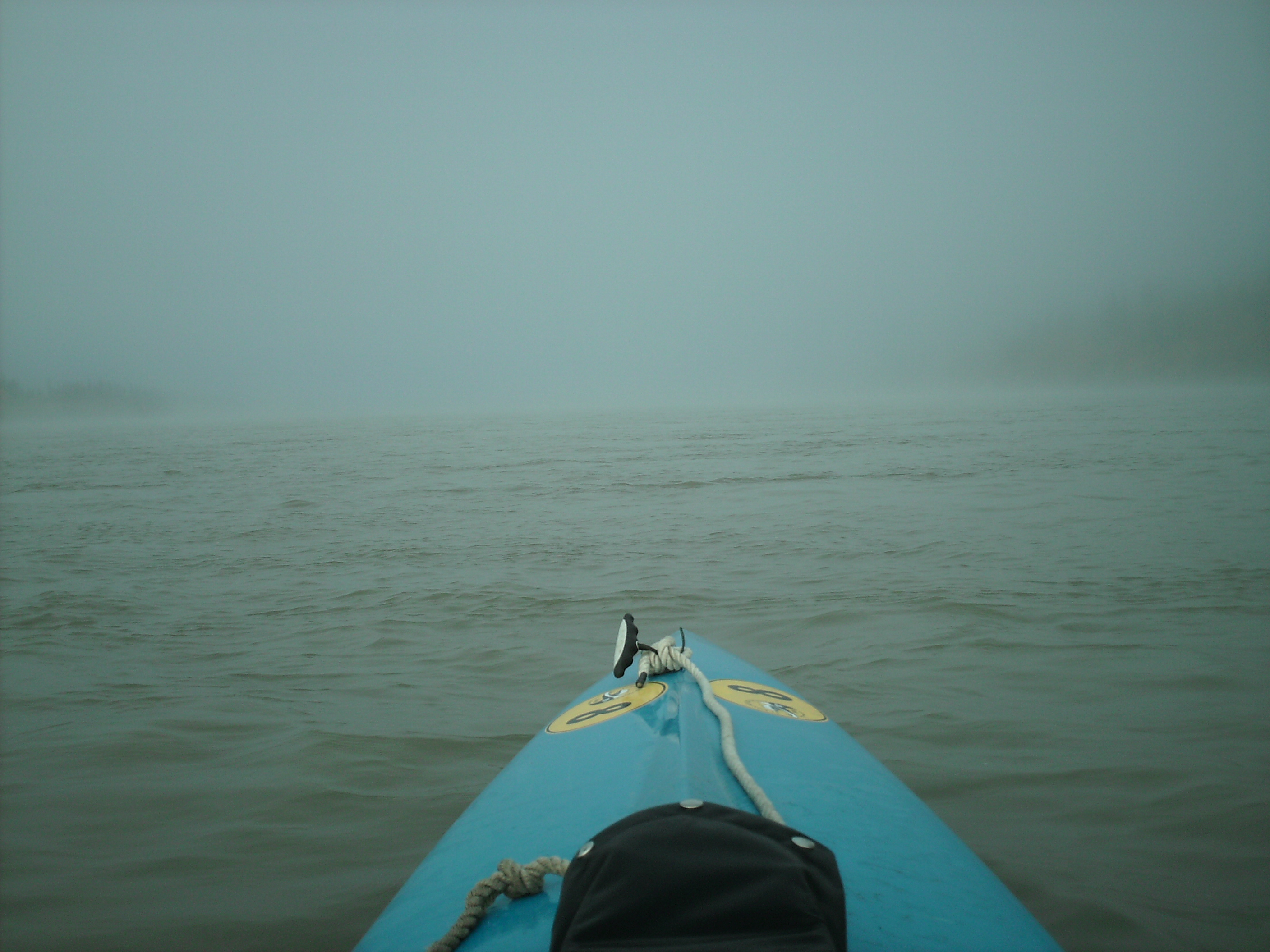
Paddling unable to see anything is very strange. I'm glad the GPS told me where I was going, but it kept losing signal. The fog lifted before I was half way through the canyon. I took photos of the bridge every ½ km from 5 ½ km away when I could first see it. Now lunch, Fairbanks, and home.

10:45. I was early.
 11:15. Anne arrived. She was early too, but not early enough.